
Isère RD211 in Record Time
I camped in le-Bourg-d'Oisans at the foot of Isère Route Department 211. As the weather was glorious so I went for a ride up RD211 which I rode in a personal best of 2 hours 37 minutes and 63 photos. RD211 is famous for some boring reason which occurs in France in July.
©Stephen Dee
ID 2010-09-14-40081 (L) 2010-09-14-40143(R)
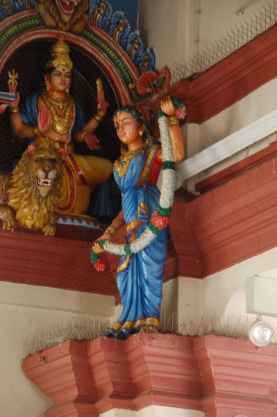
Chinatown Peoples Park
A air condition Indoor Market would be better description rather then shopping Mall
©Stephen Dee
ID 2011-12-03-44011
Views Down Towards le-Bourg-d'Oisans From Isère RD211
When looking down from the RD211 one can get an idea of the windy nature of the road. Top left hand corner is le-Bourg-d'Oisans, altitude about 715m. Middle left is La Garde en Oisans, altitude 985m. The little road middle left is RD211a which is the road I descended from Col de Cluy. This view was taken at hairpin 11 at 1195m after an hour of cycling and photography.
©Stephen Dee
ID 2010-09-14-40113
Hairpin 8
On hairpin 8 is Eglise Férréol
©Stephen Dee
ID 2010-09-14-40120
Huez
Between haipin 6 and 5 is the village of Huez. From here there is an alternative descent route via RD211b and RD44b which looks very interesting on the map.
©Stephen Dee
ID 2010-09-14-40123
Huez
After the mandatory celebratory photos I has a brew prior to the more interesting part of ride.
©Stephen Dee
ID 2010-09-14-40149
Huez
This was the real reason for riding up RD211 - the roads and tracks beyond l'Alpe d'Huez. Route Pastorale du Col de Sarenne is the type of road the "roadies" who ride up RD211 do not like as it is covered with loose grit and by frequent gullies which form cobbled troughs across the road. Not the sort of surface you want when riding on 18mm tyres.
©Stephen Dee
ID 2010-09-14-40150
Col de Cluy
A sort way along Route Pastorale du Col de Sarenne one had a wonderful across Col de Cluy to the mountains around Les Deux Alpes. Below is another view taken nearby. I descended via Col de Cluy along the track that goes left to middle.
©Stephen Dee
ID 2010-09-14-40151 (above) 2010-09-14-40153 (below)
Col de Sarrene
This was my first 2000m col, however it depends on from you take the height from. On the IGN Top 100 maps it is marked as 2009m. However IGN 50K and 25K maps show the col marked as 1999m. Additionally historic photos show the col marked with its name, which was clearly absent when I visited.
©Stephen Dee
ID 2010-09-14-40157
The Track to Col de Cluy
The track over Col de Cluy started about 2Km west of Col de Sarrenne at a height of 1830m. It descends to about 1720m before an easy climb up to Col de Cluy. The track is a nice easy dirt track all the way.
©Stephen Dee
ID 2010-09-14-40164
Col de Cluy
Col de Cluy is marked with a simple wooden sign giving name only, which has been supplemented by a smaller plaque giving name and height as 1801m.
©Stephen Dee
ID 2010-09-14-40168
Elf & Safety
The sign needs little translation, apparently I had descended a dangerous road!.
©Stephen Dee
ID 2010-09-14-40179
Chapelle St Ilpise et St Argon
Just before hitting the tarmac of RD211e at St Giraud, one passed this chapel which is marked on the map as Cluy.
©Stephen Dee
ID 2010-09-14-40183
RD211a
The descent down RD211a is not for the faint hearted, although the descent is on the cliff side not drop side. The drop is not vertical like it is in on D76 down the side of Combe Lavel, but in places there is hardly any protecting walls on the drop side and the road narrows at the frequent tunnels/snow/landslide shelters. RD211a took me back to RD211 at le Garde en Oisans, aka hairpin 16.
©Stephen Dee
ID 2010-09-14-40189 (left)
2010-09-14-40191 (below)